About the Project
Settlement Planning in the Assyrian Empire
The Assyrian Empire, at its height, controlled nearly one million square kilometers of land, stretching from Iran to Egypt. Such a massive empire appropriately brought changes to settlement systems - both those already established and brand new settlements. By investigating Qach Rresh on the Erbil Plain, we are exploring what a brand new village founded during the empire's most powerful period looks like, and what that can tell us about Assyrian strategies of settlement.
|
Deportee Populations in the Imperial Heartland
The Assyrian Empire expanded through massive warfare and violence, conquering peoples who were originally part of other states, kingdoms, or nomadic groups. As a tactic of controlling these populations after they had been conquered, the Assyrian Empire practiced "deportation" - or, moving and resettling these peoples in different locations throughout the empire (sometimes thousands of kilometers away). This served two functions: it depopulated the conquered towns to weaken them further, and it extracted people from their communities and familiar land to prevent revolts. Furthermore, it has been argued that these new populations provided a source of labor that was otherwise scarce in parts of the empire. Were deportees living at Qach Rresh?
|
Agricultural Production in the Iron Age
Provisioning the massive capital cities and the extensive army of the Assyrian Empire was no small feat. Agricultural staples such as cereals and legumes had to be in ready supply to feed the growing population. This, naturally, led to an intensification of agriculture in the empire. At Qach Rresh, we will be carefully investigating the storage rooms of large buildings to recover the remains of crops that were held there. What was being grown at this small village, and how?
|
The 2022 Season
With a season lasting 5 weeks (from August 31 - October 2, 2022) the RLIIM team opened two trenches over the main building remains at Qach Rresh.
Both the buildings in Operation A and Operation B were difficult to identify based on excavation alone, due to significant deterioration in the mudbrick. By using the magnetometry data together with the excavation, we were able to come to several conclusions about the site after one season:
Both the buildings in Operation A and Operation B were difficult to identify based on excavation alone, due to significant deterioration in the mudbrick. By using the magnetometry data together with the excavation, we were able to come to several conclusions about the site after one season:
- While we believe the buildings to have been constructed in the Neo-Assyrian period, many of the artifacts collected from the Qach Rresh excavations likely date to the post-Assyrian phase of the Iron Age (c. 600-500 BCE). This conclusion is based on the post-Assyrian forms of the ceramics and the common use of grit instead of chaff as a temper.
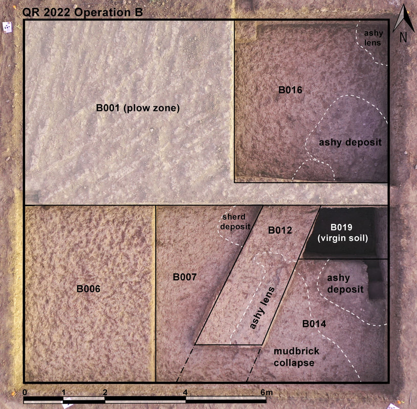
- The rooms of Building B (in Operation B) were used as a dump in the post-Assyrian period.
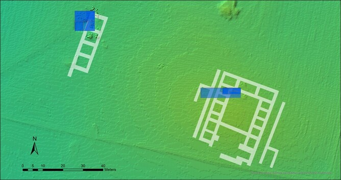
The placement of Operations A (southeast trench) and B (northwest trench) over the building walls identified in the magnetometry.
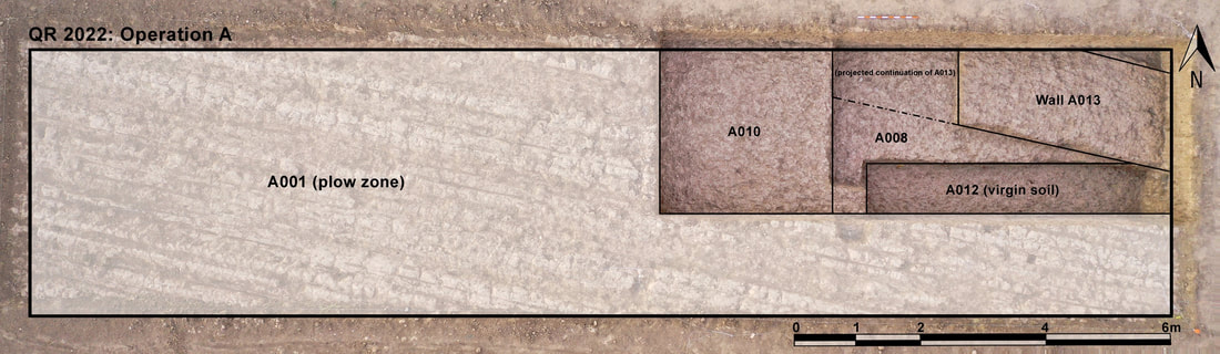
In Operation A we excavated down in 20cm intervals with the intention of uncovering a large set of walls bounding the northwestern part of the courtyard in the main building identified through magnetometry. At a depth of around 50cm, the texture of the soil matrix began to harden, becoming thick and difficult to excavate. While the walls were difficult to identify due to this uniform matrix, we were able to distinguish the wall (A-013) running roughly from NW-SE based on a pit that had been cut into the fill of the building. The pit itself was filled with ash, charcoal, animal bone, and broken pottery.
It quickly became evident that the western half of the trench was very similar in soil type to much of Op. A, where calcium carbonate crystals were intermingled with dark brown, thick soil. In the eastern half of the trench, however, we began to collect large amounts of sherds and animal bones beginning at a depth of 35cm. To focus our efforts, we separated the trench in half and continued to excavate in the eastern half, while also opening a 4x5m area in the northeastern corner of the trench. Based on soil color and texture, we were able to estimate the orientation and thickness of the mudbrick wall bounding the room on its western side. We designated this wall before continuing to excavate the room’s fill.
|
The room excavated in Building B (Op. B) this season contained at least 130cm of fill from trash deposition. Below these multiple deposition events (which can be identified in the stratigraphy of the baulk) there was what appeared to be roughly 55cm of mudbrick collapse, likely from the roof of the building. Below this, there was a 30cm thick layer of hard-packed clay with very few artifacts. We interpret this layer to be the remains of the foundation trench constructed before Building B was built.
|
|
While initially we approached Qach Rresh believing it to be occupied only in the late Neo-Assyrian period (c. 750-600 BCE) we now recognize that it was also used in the post-Assyrian period. The buildings may have been constructed in the Neo-Assyrian period, abandoned, and then reused in the post-Assyrian period, based on preliminary interpretations of the ceramic material. Overall, we are also interested in the potential to investigate the post-Assyrian occupation of the Erbil Plain, considering it has been largely underrepresented in archaeological studies.
|
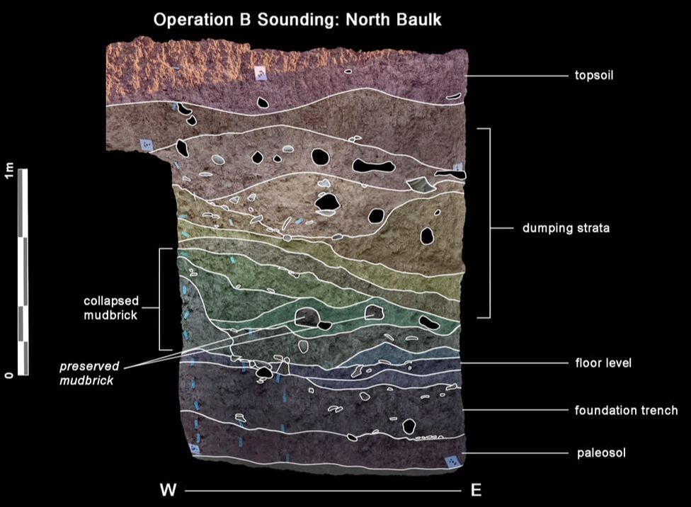
The section drawing of Operation B's sounding (B-019), showing several deposition events.
|
